The sea tells you its intentions long before it shows them. You smell it first—a sudden, heavy metallic tang on the midnight air, like wet copper pennies dropped in salt. Then the barometer drops. That dull, sickening pressure behind your eardrums tells you the atmosphere is cracking open.
Out on the open water, far from the safety of concrete seawalls and Doppler screens, the transformation happens in the dark.
For days, Tropical Storm Karina had been a lazy, spinning bruise on the surface of the eastern Pacific. It was a weather map icon, a swirl of white clouds tracked by tired meteorologists drinking lukewarm coffee in air-conditioned offices. It was something people read about over morning toast and promptly forgot.
Until it woke up.
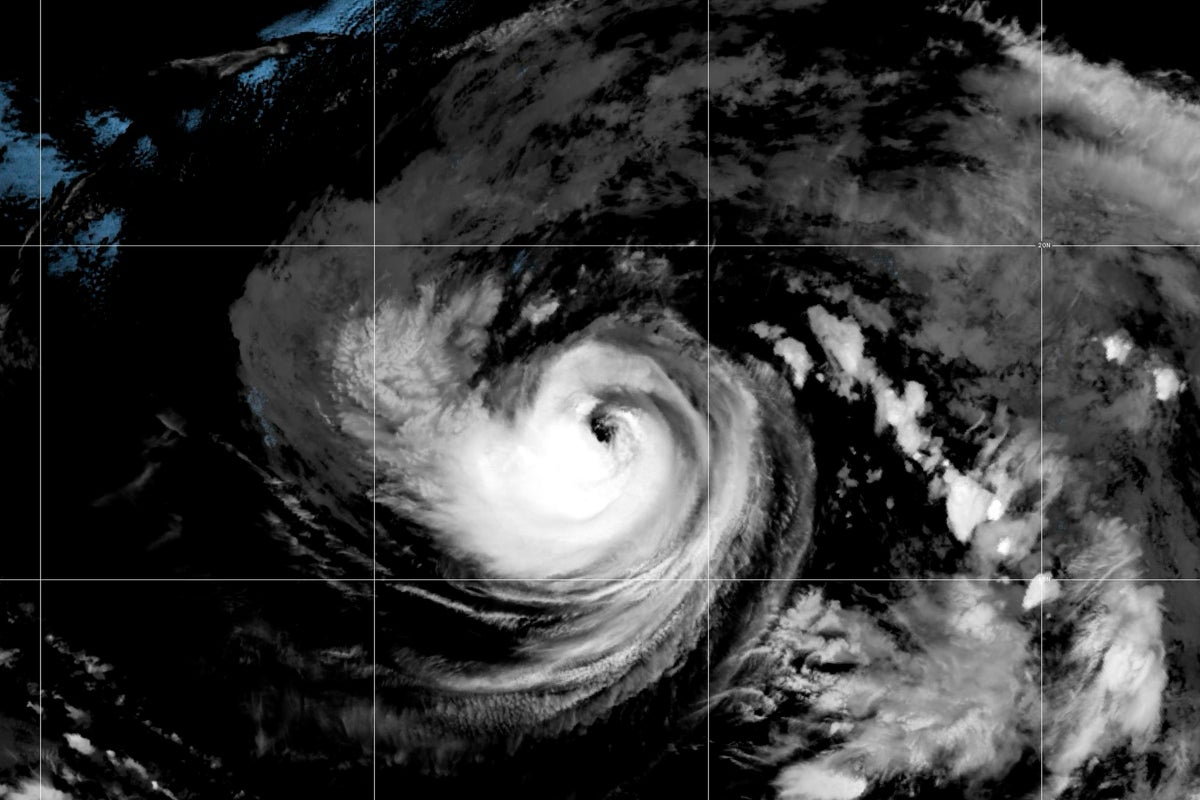
Meteorologists staring at infrared satellite loops watched the core tighten. The storm didn't just grow; it condensed, pulling moisture and heat from the ocean surface like a biological engine drawing its first true breath. Wind speeds climbed. Sustained gales crossed the threshold. By the time the advisory updates flashed across the national forecasting networks, the bureaucratic label of "tropical storm" had dissolved.
Karina was a hurricane.
The Weight of a Name
We treat weather reports like sports scores. Category one. Wind speeds at eighty miles per hour. Pressure dropping to nine hundred ninety millibars. Numbers on a screen.
Data strips the terror away. It sanitizes the ocean.
Imagine standing on the deck of a commercial fishing vessel three hundred miles off the coast when the transition happens. (To be clear, this is a reconstruction based on decades of maritime accounts during similar rapid intensification events.) The swell stops rolling in predictable, rhythmic pulses. The ocean surface flattens into an unnatural, oily glass. The air goes completely dead. Not a whisper of wind.
That silence is worse than the howling. It is the breath held before the strike.
Then comes the white wall.
When forecasters updated their bulletins to declare Karina a fully formed hurricane, they weren't just updating a spreadsheet. They were sounding an alarm for an invisible frontier. In the Pacific basins, storms like Karina often churn through vast, empty expanses of blue, safely away from population centers. But emptiness on a map does not mean nothing is listening. Cargo ships, research vessels, and migratory marine life all share that same restless water column.
The physics of rapid intensification are deceptively simple and terrifyingly violent. Warm ocean water acting as fuel. Low vertical wind shear acting as an open highway for the rising heat. When these two variables align, a storm stops meandering and starts feeding.
Reading the Invisible Signs
Why do these sudden shifts catch us off guard, even with modern satellites hovering miles above the earth?
Because nature does not care about our update schedules.
Forecasters rely on continuous streams of data from geostationary satellites, hurricane hunter aircraft, and ocean buoys that bob like corks in the abyss. When Karina crossed the threshold into hurricane status, the satellite imagery revealed a distinct, pinhole eye trying to form—the signature of a system organizing its fury.
To translate that into human terms: imagine trying to predict the exact moment a tightly coiled steel spring snaps when someone keeps adding weight to it. You know it will break. You can calculate the tensile strength of the metal. But the precise second of the fracture remains a chaotic variable.
For coastal communities watching the swell propagation days in advance, the shift from tropical storm to hurricane changes the math entirely. High surf warnings become mandatory evacuations. Rip currents turn invisible beaches into traps. The ocean begins to heave, pushing long-period waves toward shores hundreds of miles away before the storm itself even gets close.
The Aftermath of the Warning
The advisory is out. The storm is named, categorized, and tracked.
Yet the true story of a hurricane like Karina is never written in the meteorological summaries. It is written in the sudden rush at hardware store registers for plywood and bottled water. It is written in the anxious phone calls made to aging parents living near low-lying shorelines. It is written in the long, silent hours that night watchers spend listening to the rain begin to lash against windowpanes, wondering if the roof will hold this time.
Data tells us what the storm is doing. Human memory tells us what it can take.
Karina will eventually churn out its energy over colder northern waters, fading back into the vast, indifferent expanse of the Pacific, leaving behind only historical coordinates in a marine archive. But the brief hours of its strengthening remind us of a humbling truth we spend most of our lives trying to forget.
We build our cities out of glass and ambition, but we live on the edge of an ocean that can rewrite the landscape in a single night.
The wind rises. The barometer hits the floor. And the dark water waits.