The probability of extracting alive individuals from collapsed structures decays exponentially over time, typically precipitating a critical operational bottleneck at the 72-hour mark. In disaster medicine and structural engineering, this is governed by the survival function of trapped victims, where asphyxiation, dehydration, and crush syndrome operate as the primary lethal mechanisms. Traditional search methods rely heavily on unstructured physical clearing, which introduces two fatal flaws: extreme time inefficiencies and the high risk of secondary collapses triggered by the search teams themselves. To maximize the volume of successful extractions, modern urban search and rescue (USAR) must be analyzed not as a series of heroic interventions, but as a multi-modal optimization problem.
Optimizing this survival window requires a highly coordinated, tri-layer deployment strategy. This framework categorizes search assets into three distinct operational vectors: biological detection (canine units), remote aerial reconnaissance (unmanned aerial vehicles), and localized acoustic telemetry (seismic and acoustic sensors). Each layer possesses distinct physical constraints, signal-to-noise ratios, and operational velocities. By understanding the precise mechanics, limitations, and failure points of these three layers, incident commanders can systematically reduce the time-to-detection metric, shifting the operational curve to save more lives before environmental and physiological limits are reached. Don't miss our previous post on this related article.
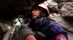
Biological Detection: The Kinetic and Chemical Constraints of Canine Search
Canine search units remain the most agile dynamic sensors available in unstructured collapse environments, yet their deployment is strictly bound by fluid dynamics and chemical volatility. Unlike mechanical sensors, a search canine relies on the detection of volatile organic compounds (VOCs) sloughed off by living human skin and respiratory processes. These compounds travel through the voids of a collapsed building via convective air currents and concentration gradients, forming an odor plume.
The primary operational bottleneck in biological detection is the unpredictability of this plume. Structural collapses rarely leave open vertical pathways; instead, they create complex, tortuous networks of debris. To read more about the background here, Associated Press offers an in-depth breakdown.
- Thermal Inversions: During peak daylight hours, the sun heats the upper layer of concrete debris, creating a localized high-pressure zone that suppresses cooler air trapped within the voids. This prevents VOCs from rising to the surface, rendering canine detection highly ineffective until ambient temperatures drop.
- The Chimney Effect: Wind blowing across a collapsed structure creates low-pressure pockets on the leeward side, pulling air—and consequently, the victim's scent—away from the actual physical location of the survivor. A canine may alert aggressively at an egress point that is dozens of meters away from the source trapped deep within the rubble matrix.
- Olfactory Fatigue and Saturation: A canine's olfactory receptors can become saturated within 20 to 30 minutes of continuous tracking in environments contaminated by ambient disaster pollutants, such as ruptured gas lines, decomposing organic matter, or burning plastics.
Because of these variables, biological detection cannot be treated as a pinpoint localization tool. It functions properly only as a macro-filtering mechanism. A canine alert establishes a high-probability zone, which must then be verified and cross-referenced by secondary and tertiary mechanical layers to prevent wasted excavation time.
Remote Reconnaissance: Kinetic Limitations of Aerial Orthomosaics and Thermal Imaging
Unmanned aerial vehicles (UAVs) provide immediate structural topology assessment, shifting the initial phase of USAR from blind entry to targeted deployment. The utility of a drone in a post-earthquake scenario is governed by two sensor payloads: high-resolution optical cameras used for photogrammetry and Long-Wave Infrared (LWIR) sensors used for thermal anomaly detection.
[UAV Aerial Survey] ──> Identifies Macro Structural Anomalies & Surface Thermal Signatures
                                 │
                                 ▼
[Canine Deployment] ──> Narrows Search Zone via Volatile Organic Compound (VOC) Plumes
                                 │
                                 ▼
[Acoustic Telemetry] ──> Pinpoints Micro-Vibrations and Structural Egress Points
Photogrammetry software processes sequential aerial images to construct a 3D orthomosaic map of the disaster zone. This allows structural engineers at the command post to identify structural failure types—such as pancake, cantilever, or lean-to collapses—before ground teams enter. This categorization dictates where survival voids are statistically most likely to exist.
LWIR sensors operate on wavelengths between 8 and 14 micrometers, detecting radiation emitted by surfaces based on their temperature. The operational thesis is that a human body trapped near the surface will conduct heat through the debris, manifesting as a thermal hotspot. However, the physical limitations of infrared radiation introduce severe operational constraints:
- Thermal Obfuscation: Concrete, brick, and rebar possess high thermal mass. If a victim is buried deeper than 0.5 meters beneath dense concrete, the thermal energy generated by the human metabolism (approximately 100 watts at rest) is entirely absorbed and dissipated by the material.
- Solar Loading: During daylight hours, solar radiation heats exposed concrete and metal fragments to temperatures far exceeding human body temperature. This creates massive environmental noise, blinding the LWIR sensor. Thermal reconnaissance is therefore strictly limited to the twilight and nocturnal windows, where the background substrate cools, increasing the signal-to-noise ratio of a living human signature.
- Kinetic Voids: Drones cannot navigate the interior subterranean voids of a collapsed concrete structure due to the immediate loss of Global Navigation Satellite System (GNSS) signals and the high probability of kinetic impact with hanging debris. Their role is strictly limited to macro-mapping and surface-level triage.
Localized Acoustic Telemetry: Seismic Wave Propagation and Environmental Noise Filtration
Once macro-mapping and canine alerts narrow the geographic focus to a specific structural footprint, technicians deploy acoustic and seismic listening devices. These systems utilize arrays of geophones and highly sensitive acoustic microphones to detect micro-vibrations, scratching, or vocalizations originating from survivors trapped deep within the rubble.
The underlying physics relies on elastic wave propagation through solid mediums. When a trapped survivor strikes a concrete slab, the kinetic energy transforms into seismic waves—specifically P-waves (compressional) and S-waves (shear)—that travel through the structural elements of the building. Concrete is an excellent conductor of these waves, allowing signals to travel significantly farther through structural beams than through the open air.
The primary technical hurdle is the signal attenuation and refraction that occurs at material interfaces. Every time a seismic wave travels from a concrete slab, through an air gap, and into another layer of brick or soil, a massive portion of the energy is lost to reflection. A multi-layered pancake collapse acts as a acoustic dampener, rapidly degrading the signal strength.
To counteract this, modern acoustic arrays utilize a minimum of three geophones placed in a geometric pattern across the collapse surface. By measuring the minute differences in time-of-arrival (Delta-T) of the seismic wave at each specific geophone, the processing unit uses triangulation algorithms to compute the exact vector of the source.
       [Geophone 1] (Receives wave at t=0ms)
            │
            ├───> [Central Processing Unit] ──> Calculates Delta-T ──> Pinpoints Source
            │                                                              Location
       [Geophone 2] (Receives wave at t=12ms)
The second limitation is ambient acoustic pollution. In an active disaster zone, heavy machinery, secondary seismic settling, wind, and nearby generators produce continuous, high-amplitude acoustic interference. To extract a victim's low-amplitude tapping from this background noise, systems must employ real-time digital signal processing (DSP). This involves applying band-pass filters that isolate the specific frequency bands of human scratching (typically 1 kHz to 3 kHz) and human vocalizations, while digitally subtracting the low-frequency rumble of diesel engines and heavy equipment.
Systemic Bottlenecks: The Integration Failure of Fragmented Data Streams
The primary reason search and rescue operations fail to optimize the 72-hour survival window is not a lack of sensor capability, but a breakdown in data integration. Currently, canine handlers, drone pilots, and acoustic technicians operate as independent silos. They pass qualitative, fragmented reports up to a central command post, where information is manually synthesized on physical maps or rudimentary digital overlays.
This structural fragmentation creates a dangerous operational bottleneck. A canine alert may be recorded in a sector, but without the immediate overlay of the drone’s 3D structural collapse map, engineers cannot determine if digging at that alert site will destabilize a cantilevered slab directly above another suspected survivor zone.
Furthermore, data latency slows down the deployment loop. If an acoustic team identifies micro-vibrations, that data must be instantly cross-referenced with the thermal anomalies captured by UAVs hours prior to confirm a high-probability strike. When these data streams remain unaligned, valuable hours are expended verifying false positives or clearing low-probability debris fields while viable victims succumb to environmental exposure.
Dynamic Resource Allocation Protocol
To maximize survival rates, incident commanders must abandon linear deployment models and implement a dynamic, data-driven resource allocation protocol that shifts assets based on real-time environmental and physical metrics.
[Phase 1: 0-12 Hours] High-Velocity Aerial Reconnaissance & Structural Triage
                                │
                                ▼
[Phase 2: 12-36 Hours] Nocturnal Thermal Scanning & Canine Macro-Filtering
                                │
                                ▼
[Phase 3: 36-72 Hours] High-Density Acoustic Triangulation & Precision Excavation
Phase 1: The Macro-Filtering Stage (Hours 0–12)
Immediate priority must be given to high-velocity aerial reconnaissance. UAV flights must be executed within the first hours to generate a complete 3D orthomosaic map of the affected region. Ground teams must not be randomly dispersed; they must wait until the structural triage map identifies the highest density of high-probability void spaces (e.g., lean-to and pancake formations over residential structures).
Phase 2: The Multi-Sensory Validation Stage (Hours 12–36)
Canine units are deployed to the high-probability structural zones identified in Phase 1. To mitigate olfactory fatigue, handlers must operate on strict 20-minute rotational shifts. Every canine alert must be digitally logged with precise GPS coordinates. During the nocturnal transition, when solar loading dissipates, UAVs equipped with LWIR sensors must re-survey the canine alert zones to cross-reference surface thermal anomalies with the biological signatures.
Phase 3: The Micro-Localization Stage (Hours 36–72)
Acoustic and seismic monitoring arrays must be deployed exclusively to the intersection zones—the precise points where canine alerts and thermal anomalies overlap. Heavy machinery within a 200-meter radius must be ordered into complete mechanical shutdown for 15-minute intervals every hour to allow acoustic technicians to capture pristine seismic data without industrial noise contamination. Once triangulation algorithms pinpoint the source vector, surgical excavation teams are deployed with heavy hydraulic cutting tools to breach the structure along the path of least resistance, bypassing stable load-bearing elements to eliminate the risk of secondary structural collapse.